> ## Documentation Index
> Fetch the complete documentation index at: https://help.parafin.ai/llms.txt
> Use this file to discover all available pages before exploring further.
# Using the Zoning Panel
> Find every available zoning detail for your site in one place — district codes, dimensional controls, and direct links to municipal sources.
{/* Figma source: Viever Zoning (full panel) https://www.figma.com/design/hevlKEYRL9U8bXkXiKqMky/Parafin?node-id=11596-100411 */}
The Zoning Panel brings every available zoning detail for your site into a single location. Review district codes, permitted uses, dimensional controls, and direct links to the municipal source, all from inside your project.
## Zoning awareness
When zoning data is available for your site, a blue information card appears in the project panel with the heading **Zoning Data Available For This Site**. The card explains that Parafin provides local zoning data for height, FAR, open space, and setbacks, and that you can use this information to adjust filters and define building setbacks.
Two buttons on the card let you act immediately:
* **Review zoning**: opens the full Zoning Panel
* **Ignore For Now**: dismisses the card and continues with your current settings
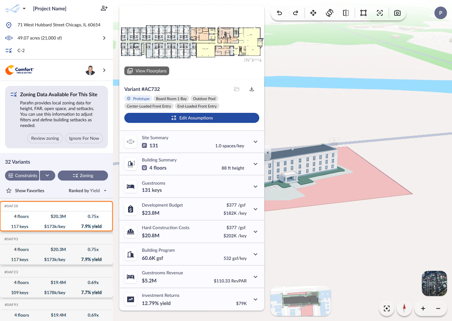 The card appears below the brand information and above the variant list. It stays visible until you click one of the two buttons.
## Opening the Zoning Panel
Click the **Zoning** button in the project panel (next to the **Constraints** button) to open the full Zoning Panel at any time. The panel opens in the center of the screen with the heading **Street Frontage and Setbacks**.
If your parcel doesn't show zoning data, your jurisdiction may not yet be in the Zoneomics feed. [Let us know](mailto:support@parafin.ai) and we'll add it in the next weekly update.
## What's in the panel
The Zoning Panel shows the site address, acreage, and zoning code at the top, then expands into two main sections:
The card appears below the brand information and above the variant list. It stays visible until you click one of the two buttons.
## Opening the Zoning Panel
Click the **Zoning** button in the project panel (next to the **Constraints** button) to open the full Zoning Panel at any time. The panel opens in the center of the screen with the heading **Street Frontage and Setbacks**.
If your parcel doesn't show zoning data, your jurisdiction may not yet be in the Zoneomics feed. [Let us know](mailto:support@parafin.ai) and we'll add it in the next weekly update.
## What's in the panel
The Zoning Panel shows the site address, acreage, and zoning code at the top, then expands into two main sections:
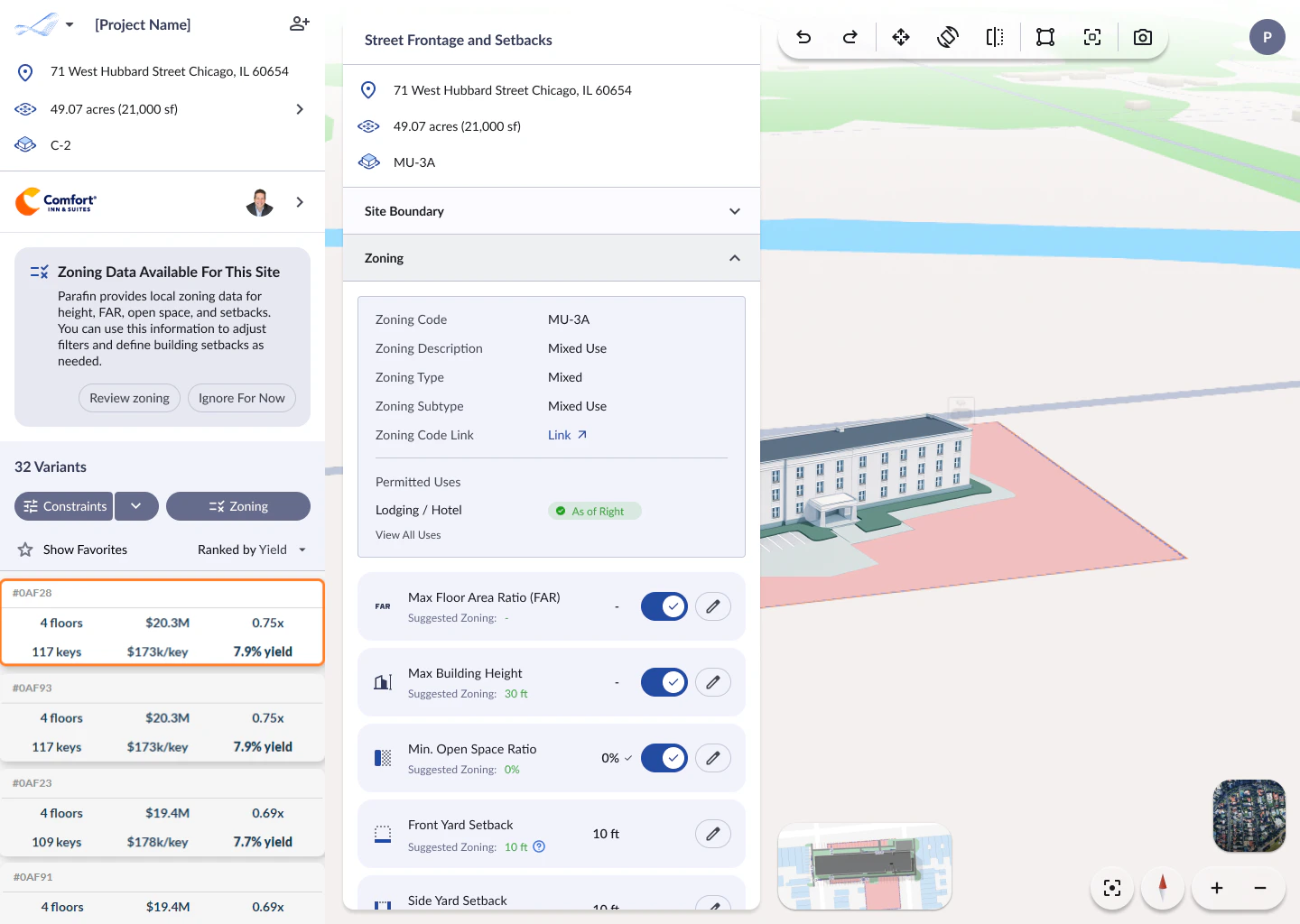 The panel has three areas: zoning details at the top, permitted uses in the middle, and constraint controls at the bottom.
### Zoning details
| Field | What it tells you |
| ---------------------- | ------------------------------------------------------------- |
| **Zoning Code** | The official zoning designation for your parcel (e.g., MU-3A) |
| **Zoning Description** | A plain-language summary (e.g., Mixed Use) |
| **Zoning Type** | The broad category: residential, commercial, mixed, etc. |
| **Zoning Subtype** | A more specific classification within the type |
| **Zoning Code Link** | A direct link to the municipal source for the full code |
### Permitted uses
The **Permitted Uses** section shows whether your intended use (Lodging / Hotel) is allowed in the zoning district. A green **As of Right** badge means the use is permitted without special approval. Click **View All Uses** to see the full list of permitted uses for the district.
### Constraint controls
Below the zoning details, each dimensional constraint shows a **Suggested Zoning** value and a toggle to apply it:
* **Max Floor Area Ratio (FAR)**: the maximum ratio of building area to site area
* **Max Building Height**: the maximum building height allowed (e.g., 30 ft)
* **Min. Open Space Ratio**: the minimum percentage of the site that must remain open
* **Front Yard Setback**: the required distance from the front property line
* **Side Yard Setback**: the required distance from the side property lines
Each constraint has a **toggle** to enable or disable it and an **edit button** to enter your own value. Zoning sets the baseline. You can make constraints more stringent, but not less stringent than the zoning code allows.
Click the **Zoning Code Link** to open the full municipal code in a new tab. Bookmark frequently-used jurisdictions. The links are stable and update with the parcel data.
For the full constraint controls (not just zoning-derived ones), see [Constraints and sorting](/working-with-projects/constraints-sorting). For setback editing and side labeling, see [Setbacks and adjacency](/working-with-projects/setbacks-adjacency).
The panel has three areas: zoning details at the top, permitted uses in the middle, and constraint controls at the bottom.
### Zoning details
| Field | What it tells you |
| ---------------------- | ------------------------------------------------------------- |
| **Zoning Code** | The official zoning designation for your parcel (e.g., MU-3A) |
| **Zoning Description** | A plain-language summary (e.g., Mixed Use) |
| **Zoning Type** | The broad category: residential, commercial, mixed, etc. |
| **Zoning Subtype** | A more specific classification within the type |
| **Zoning Code Link** | A direct link to the municipal source for the full code |
### Permitted uses
The **Permitted Uses** section shows whether your intended use (Lodging / Hotel) is allowed in the zoning district. A green **As of Right** badge means the use is permitted without special approval. Click **View All Uses** to see the full list of permitted uses for the district.
### Constraint controls
Below the zoning details, each dimensional constraint shows a **Suggested Zoning** value and a toggle to apply it:
* **Max Floor Area Ratio (FAR)**: the maximum ratio of building area to site area
* **Max Building Height**: the maximum building height allowed (e.g., 30 ft)
* **Min. Open Space Ratio**: the minimum percentage of the site that must remain open
* **Front Yard Setback**: the required distance from the front property line
* **Side Yard Setback**: the required distance from the side property lines
Each constraint has a **toggle** to enable or disable it and an **edit button** to enter your own value. Zoning sets the baseline. You can make constraints more stringent, but not less stringent than the zoning code allows.
Click the **Zoning Code Link** to open the full municipal code in a new tab. Bookmark frequently-used jurisdictions. The links are stable and update with the parcel data.
For the full constraint controls (not just zoning-derived ones), see [Constraints and sorting](/working-with-projects/constraints-sorting). For setback editing and side labeling, see [Setbacks and adjacency](/working-with-projects/setbacks-adjacency).